Sendero Lagunas Altas | Tourist Attraction
Chile
Details
- Verified:
- 12 days ago
- GPS:
- -47.12986, -72.50552
- Altitude:
- 477.5 masl
- Contributor:
-
 weltkugelschreiber.de

Amenities
Something not right?
Description
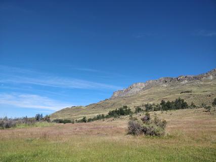
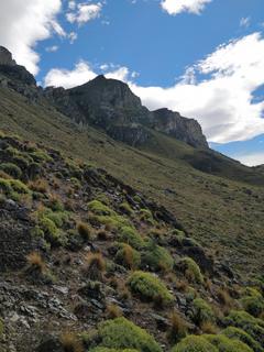
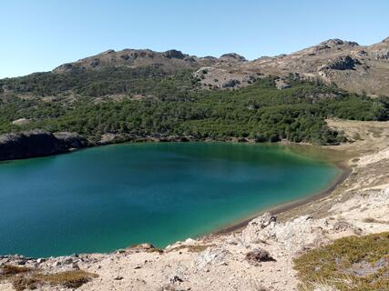
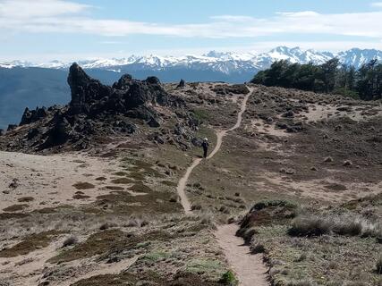
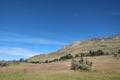
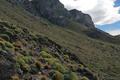
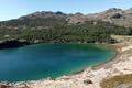
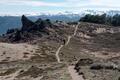
The 19.5 + 1.5 km sendero is one of the most popular in Parque Patagonia. The info material says it's a 6–10 hrs walk. The trail starts right next to the campground Westwinds, leads to a parking spot and then you follow the path uphill. First 6.5 km are the hardest, going up a few hundred meters in slopes, but the path is good, easily manageable. After that, you're almost on top of the mountain, walking by several lagunas on almost even ground. Another maybe 7 km afterwards, descent starts. It's never too steep and you will have a lot of great views. Definitely a recommendation.
If you're coming from the info center, make sure to stop at the second parking space, as the first one is the end of the trail! It is much better done counter-clockwise, it was designed that way for the best hiking experience.
Full day, 21 km
Intermediate/advanced difficulty
Ascent: 1039 m
Why? By checking in after you’ve visited a place you let others know this place is still functional. You can also add or correct any information.
Latest Check-Ins
Amazing hike! at this time of the year all the trees are red and the water reflects them.
Report Check-InAmazing hike! Great views in a constantly changing environment. Lots of wildlife. We did it counter clockwise. Very quiet in the park. Trail is very good visible. Near the visitor centre is also the cemetery where Douglas Tompkins is buried. WiFi is available for free at the visitor centre under the name of STINKY. Not the fastest, but it works!
Report Check-InIf you try to get here and you come from the north, make sure to drive down to the visitor center. The sign before leads to a very small road with mamy thorny things on the side.
Report Check-InWe saw two other couples along the whole hike. It was beautiful, so peaceful, lots of guanacos, many with babies! Friends saw two pumas so keep your eyes open. Highly recommended. As said before: anti clockwise is best to get the hard part over with quickly, after about 6,5km the climbing is mostly done! Enjoy, I'm sure you will.
Report Check-InIt may be the most popular, but we only saw 3 other people right in the middle of high season. Really great hike. Agree with the last guy! Trail designer deserves a medal.
Report Check-InAt Lamington NP in Queensland the man who constructed the paths watched how the cows walked and built them accordingly, so although you have big hikes you never feel tired. This is the same: it's a long day but quite doable! Anti clockwise, the first 4 km are easy, the next 2 a bit steeper but fine and there is really only one steep-ish section around the 6 km mark. Once the first mirador is reached just after 6 km all the hard work is done and it is straightforward easy walking - and the
scenery on top is absolutely stunning! We took 9½ hours with lots of stops - take your time and enjoy it, it is one of the best walks you'll do in Patagonia.
Stunning hike! Start the hike on the camping side (counter clockwise). Than you will start with the steep part and you go slightly down from kilometer 6. Search for Puma footprints on the ground :)
Report Check-InWe really liked this hike. In a clear day, you can have spectacular views of the valleys and the various lakes are always nice to look at. The hike is rather diverse. But be cautious with the optimistic walking times of the previous comments : it's a long hike and the ranger told us it takes on average 8h (btw 6 and 10 depending on your hiking experience). We did it in 7.5h without lunch break and would say we are average hikers. Be sure to begin at the second parking, it will be easier. Trail is well maintained.
Report Check-InAmazing trek and we recommend to do it counterclockwise. Quite easy in the beginning, just a small steep part before reaching the top (from km 5).
Report Check-Inwe went into the info center to ask about the hikes and they pretty much said conaf hasn’t started yet for the season and the treks are technically “closed” but at your own risk with wink. parked at the first parking lot, walked to the 2nd and made it until about km 6.5 before the top was completely covered in snow. pretty comical for a few kms and an adventure in itself but be warned if you don’t have waterproof gear you’ll get very wet this time of year !!! the snow was up to our waists in some areas :)))) took us 6.5 hours (we are fast hikers but account for time navigating the snow) , still had fun and slept in our van in the parking lot with no issues! amazing sunset and guanacos everywhere :)
Report Check-InNice day loop hike that goes on the top of the hills offering a beautifull view of the valley. The pathway pass next to few lacs of different colors.
Report Check-InIt’s a nice trail but not very remarkable compared to the rest of the trails along the carretera austral. I guess I don’t enjoy that much walking on the steppe. The trail is long (5-6hours + stops), very exposed to the sun and wind, and the views are mostly of an arid open valley.
If short on time, I would rather drive deeper into the park (alto valle) and do a shorter walk (mirador douglas tomkins).
Report Check-InAs described, very nice and diverse hike. Took us 5h10 (with a couple of small breaks). We had a partially rainy day, which impeded some of the far away views, but still nice!
Report Check-InOne of our favorite treks in Chili! Diverse, very well maintained and absolute amazing views. It's about ~20km, took us 6.5hrs including breaks.
Report Check-InGrateful for b.chaski’s to park at the first parking when we got back tired. Not a lot of shade during the descent, so make sure you’ve got enough water left. Some of the streams you’ll cross (“Step-stone bridge” in OsmAnd) are good enough to fill your bottles from.
Report Check-InEverything is already said! We loved this trek! It's a great trail, always changing and surprising! It's very well maintained and marked. You get so many nice views on the surroundings mountains and the lagunas. We so some guanacos too. It's a good day hike, but not difficult, it's slowly go up and slowly down. It's one on the best trek we have done so far in Chile!
Report Check-InWorld class trekk! You can walk hours alone contemplating nature. The 1200+ meters don't feel too hard. A variety of little lagunas, endemic forest and lookouts of the valley await for you.
Report Check-InReally beautiful hike. One of the most clean, untouched, and well marked trials we have ever done- did not see another person! Took us 5hr15min to do the full 21km. Agree with another poster who recommended leaving your vehicle at the first parking lot and walking to the start at the second parking lot (close to the campground). There’s also markers every km which is nice. First 3km (from the official start, not including the 1.5km on the road between the parking lots) are a mild incline. Next 4km are overall uphill with a lot more steep portions. After that it’s all pretty flat until the last few Kms of descent. Really nice trail, would definitely recommend. We left early and were done by 1pm
Report Check-InBeautiful Hike !
It took us 6.5hours with breaks at different miradors and lunch.
We started at 7.30am and got back little bit before 2pm.
There is two parking with the information "Laguna Altas" the beginning is at this point but you should actually park the car at the first one and do the 1.5km at the beginning so you don't have to do it at the end of the trek (if tired).
The trail is 19.5km plus 1.5km in between the 2 parking lots.
It start with 7km going up with the steepest part between km 6&7 but with great view over the valley.
After is gonna be 7kms pretty flat with forest and lagoons and 5.5km going down with amazing views.
The first lagoons is the nicest one with it's blue colors even if the others are nice too.
Absolutely no one all day on this trek we were completely alone.
Enjoy it !
great hike! many wildlife : guanaco, condor, rabbit, many birds.
Report Check-InVery windy for 7-8km from campground. After that sheltered a bit behind cliffs. Relatively easy distance some small steep/ rocky areas but mostly clean trail. Weather was cold/ rainy so not many stops pumped it out in just a hair over 5 hours.
Report Check-InThe 23 km Sendero is one of the most popular in Parque Patagonia. The info material says it's a 6-10 hrs walk, it took us (fairly untrained) about 9-9.5, but we took our time and a lot of photos (feel free to check them out on my website). The trail starts right next to the campground West Winds, leads to a parking spot and then you follow the path uphill. First 6.5 km are the hardest, going up a few hundred meters in slopes, but the path is good, easily manageable. After that, you're almost on top of the mountain, walking by several lagunas on almost even ground. Another maybe 7 km afterwards, descent starts. It's never too steep and you will have a lot of great views. Definitely a recommendation.
Location is approx, you'll see a sign where the trail starts on the campground. You can also start from the parking space/trailhead, but if you're coming from the info center, make sure to stop at the second parking space, as the first one is the end of the trail!
Full day, 23 km (14 miles)
Intermediate/advanced difficulty
Ascent: 1268 m / 4160 ft