Check-Ins
| When? | Who? | Comment | Place | Location |
|---|---|---|---|---|
|
augustin.filiber
|
we had a great night here (on week day)
|
Cascadas Agua Azul | 17.25690, -92.11336 | |
|
The Nomadic Experience
|
Stayed 2 nights here while going back and forth to strands beach, didn’t have any issues. Other vehicles parked both nights. |
Starview Lane, Laguna Niguel | 33.50884, -117.72877 | |
|
alwaysonvacay.life
|
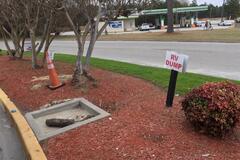
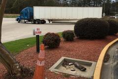
Very tiny little spot if you are blind you will miss it!!! Look in the corner of Shell gas station is right there in the corner a small sign said “RV Dump” at first I read no dump but then I figured said rv dump lol have a cone too! Its Free and doesn’t have water just dump |
Petro Stopping Center | 34.26682, -79.73121 | |
|
||||
|
The Nomadic Experience
|
I had the place to myself with no issues. Some vehicles came and left in the morning around 7 or 8 a.m. |
Quiet culdesac | 33.45012, -117.59672 | |
|
drag.murphy
|
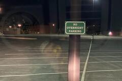
No overnight parking signs posted. Supercenter with smaller than typical lot. |
Walmart Pelham Rd Greenville | 34.86146, -82.26507 | |
|
carrothospital
|
The beach is nice and there are tons of whales playing off shore but the camping options are not the greatest. Trashy pull offs for the most part and there is a barbed wire fence blocking most access to the beach until a few hundred meters past here where the road turns a little rougher. Not really worth it in my opinion unless you need service and to be close to town. I’ve got 1-2 bars of 3G with ATT and 1 bar of LTE with Verizon. |
Pull off overlooking the ocean | 23.07903, -109.61666 | |
|
carrothospital
|
Update, this place is apparently closed. There are watchmen along this road that came up and said the owner no longer wants people camping along here. Daytime access is fine but not overnight. |
Pull off overlooking the ocean | 23.07906, -109.61665 | |
|
carrothospital
|
Private property and the guy no longer wants people camping here. There are watchmen who keep an eye on it and there’s barbed wire blocking beach access. They did say daytime access is ok but not overnight. |
Camino cabo este | 23.07602, -109.62273 | |
|
_big_blue_van
|
No sign, but clerk said it’s potable water |
Speedway Gas Station | 37.25488, -107.07807 | |
|
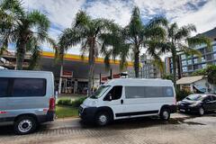
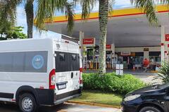
Rotas Pelo Mundo
|
Estacionamento em frente ao posto. Lugar muito calmo a noite. Tem água e banheiros no posto, além de restaurantes no entorno. Lugar bonito demais. Recomendado |
Jurere | -27.44683, -48.50231 | |
|
||||
|
trampton
|
Multiple areas and generally flat. We were able to find a spot near a fire ring. Need to bring your own wood though. Several other vans and trailers. Road was in good condition with some ruts and washed out areas. Passable with 2WD. Ok for a night but not a multiple not spot for us. |
FR 9571 | 34.80122, -111.92295 | |
|
lightm
|
Only sewer now (3/2/2021). Two months ago, there was also water. Somebody must have left it on. |
Merrigans Arizona Road-Runner RV | 32.28579, -110.99487 | |
|
facebook.com/meriveando.porelmundo
|
Es solo para casa rodantes y motorhone, costo por noche $2000, lugar muy pequeño |
Beto Estacionamiento | -38.98819, -61.32354 | |
|
vidadekombi
|
Free Shower
|
Duchas gratis | -14.82269, -74.96136 | |
|
wesley.ratliff
|
Scenic bend in the river with 3-4 flat areas, some with fire rings. Road in is steep gravel, with some big puddles in winter months. Wouldn't recommend coming here right after rains. I made it fine in an RWD van with high clearance. I suspect it would be busy here with locals on summer weekends. Google maps might point you in the wrong direction, to a road that doesn't exist. Stay on the main turn-off up the hill and come down on Forest road 6N06. |
South Fork Trinity River | 40.88162, -123.60297 | |
|
advanturezach
|
Picnic area along I10, highway noise but a good place to rest or spend the night. Lots of parking. Cell service is adequate on Verizon and AT&T. |
Picnic Area | 30.45191, -99.72297 | |
|
advanturezach
|
Good place to stay the night protected from the highway. Still audible, but not completely visible. Stayed one night, saw big bend and stayed the next night. First night was pretty standard a couple in a van took the only other easily viable spot. Second night same thing, but that second morning had a Mexican man stealthing around looking in garbages. I waved at him later on and let him use my phone to get a ride and gave him some water. But he wasn’t dressed for the weather and came out of nowhere. He was nice and respectful, but that was my luck and I have my dog with me. It’s a pretty isolated spot, so keep your wits about you. On the plus side there’s a good fence around the loop, so the only entry area is from the road. |
Picnic Area | 30.48321, -102.93063 | |
|
123forcharlie
|
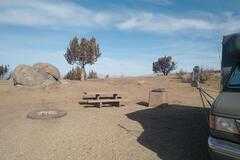
The last 100 mts to arrive to the actual spot are now very bad. There hasn’t been maintenance and the winter has left massive holes. We arrived late and had almost no visibility, so we decided to stay in the spot right before. The view is great and we felt safe.
|
Red Cliffs view | 50.04932, -110.79988 | |
|
nomadexpedition.es
|
agua potable de las canillas de la calle en la esquina de los bomberos de cholila. pedimos permiso y sin problema nos dejaron llenar el tanque de agua y las garrafas para beber. |
bomberos cholila | -42.50672, -71.43342 | |
|
||||
|
busbusbus
|
Free camping at this BLM OHV trailhead. Three sites with picnic tables, fire rings, and BBQ grills. One pit toilet (very clean!), trash cans, and an off-loading ramp for OHVs. There are another six sites at the Fort Sage TH but this one was closer to the hwy and has great views. Far enough from the road so no highway noise but we could occasionally hear a train in the distance. Very quiet and peaceful at night. OHV trails go all around here so it would probably be noisier when it's busier/weekend. 14 day camping limit and need a permit from BLM for a campfire. 4 bars LTE on Tmobile. To get here: From U. S. Highway 395 turn East on Laver Crossing road (0 .8 miles north of Doyle) and travel 1.4 miles to Hackstaff Road. Turn south (right) and travel approximately 1.2 mile to Fort Sage Road. Turn east (left) travel 1.1 mile to the entrance of the Fort Sage OHV Area. Turn east (right) and travel about 1 mile to the Diamondback trailhead, the Fort Sage trailhead is .05 miles up the road. |
Fort Sage OHV (Free) - Diamondback TH | 40.06142, -120.08360 | |
|
||||
|
christiancartwright
|
Plenty of room for an RV. Wouldn’t stay too long in Irvine. Bathrooms available they are locked at night though. Great park for dog super safe neighborhood and had an RV in the parking lot with me. |
Bill Barber Park | 33.68776, -117.81991 | |
|
||||
|
todd
|
Some NO parking signs. Probably still ok to stay here. |
Cabela's Parking | 40.43628, -111.88907 | |
|
||||
|
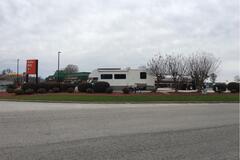
windsnobcc
|
With the $10 dump you also get unlimited water. Plus, the dump is in a decent location and right next to propane. So, if you're in need of all 3 it's a great stop. |
TA Truck Stop | 32.26861, -109.84705 | |
|
roads2africa
|
We passed by the campsite and did not stay. It's an open flat space, bucket for bucket shower still there. Unfortunately, pit toilet was filled with rubbish (beer cans etc.) This time of the year, not all roads around the pans were driveable due to heavy rains in the last weeks. You really can get stuck ! |
Pipers Pan Public Campsite Number 2 | -21.79283, 23.21472 | |
|
outintonowhere
|
Awesome spot to park and enjoy sunset and great stars at night. Super quite and safe with the guard next door. Parked here before taking the western route up to the top of Barú. The route is very strenuous and you should take a good topo map with you, but also a great hike. Tigo LTE signal. |
Barú Guard House / Entrada | 8.80970, -82.59288 | |
|
asobolife.com
|
Price is now 100Q for two people and our van. And it’s quite pricey for what you get. Our experience is good (safe and had a shower) but I wouldn’t say it’s as highly positive as the past reviewers. Maudani helped us in her land and was nice. We never met her husband, though. Overall it was a limited interaction. The bathroom is inside their house, which also means if you need to use it and it’s after 9pm-ish, you might have to knock on their door for them to come down and unlock the front door to let you in. Cold water shower, but that’s ok since we were pretty sweaty from walking around Tikal. Parking is very informal and it’s wherever you can find a flat-ish spot. It’s a little difficult to find, but after a few tries it’s possible. If we had pets, it seems this place is good to drop them off while you explore Tikal. But since we don’t have pets, and now that the price is 100Q, we think there’s not much reason to stop here. Camping at Tikal is the same price and the amenities must be better. Or you can sleep safely for free in Flores. |
Family House / Casa de familia | 17.07033, -89.68548 | |
|
whereisjayson.alwaysexploring.org
|
Small lot next to the brewery. I asked the bartender for permission and he said it was no problem. Full strength on both Verizon and AT&T. Good for a night. Food and beer were good in the brewery. There is also a sushi restaurant attached. I did not try the sushi. |
Snow Eagle Brewery & Pub | 43.49527, -112.04523 | |
|
thepowwhale
|
Open year round with dump and potable water. There are two potable water connections. Still $10 for class a and $5 for smaller on the honor system. |
Farmers Korner Wastewater Treatment Plant | 39.56661, -106.05230 | |
|
bemnaestrada.com.br
|
Acampamos ao redor da capela. Tem água e energia elétrica disponível dentro do cemitério. Lugar calmo e tranquilo. Não possui banheiros, porém nas imediações existem comércios que disponibilizam banheiros. |
Capela São Pedro do Caminho das Pedras | -29.17610, -51.43310 | |
|
onlyME
|
very nice stay - there is nothing else to say. We really love this place! |
Mount Etjo Safari Lodge | -21.02556, 16.45691 | |