Check-Ins
| When? | Who? | Comment | Place | Location |
|---|---|---|---|---|
|
amymcfarling
|
We were stopped. Pretty thorough search by nice guards. |
Military Checkpoint | 27.28814, -112.93084 | |
|
amymcfarling
|
We paid on the way down (can’t remember how much) - on the way back (north) they just waved us through |
Agriculture Control Stop | 28.06220, -114.00901 | |
|
amymcfarling
|
This one took a while. 4 cars ahead of us, each one searched (northbound). Guards were thorough but friendly. |
Military Checkpoint | 28.50877, -114.02413 | |
|
amymcfarling
|
Super friendly - waved us right through with no inspection (northbound) |
Military Checkpoint | 29.38611, -114.38142 | |
|
amymcfarling
|
Cursory inspection of camper (northbound) - super friendly guards. |
Military Checkpoint | 29.81614, -114.41932 | |
|
roads2africa
|
We just passed by, but this is no campsite, which can be booked via DWNP or Bigfoot. Must be from other Private operators (Mobile Safari camps or Hatab?) No signs seen. |
CKMO3 Campsite | -21.58826, 23.66291 | |
|
roads2africa
|
We circled the waterhole, and although everything is green and still muddy water in the hole (rainy season), there is no constant water supply here. Found a giraffe carcass nearby. |
Letiahau waterhole | -21.60801, 23.61720 | |
|
roads2africa
|
We circled the campground but did not stay. Still no facilities, nice flat ground to camp. Current visitors are ground squirrels. |
Letiahau Public Campsite - CKWIL-06 | -21.60925, 23.55608 | |
|
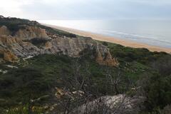
Tío Aventura
|
Awesome view, but not entirely BLM land. This section that is marked is privately owned. Another section of the land is Santa Rosa wilderness BLM this is confirmed using BLM land maps of the area and onX hunt. Road is rutted immediately coming in, road is slightly sandy and very smooth after, but took is slow in my 170” non ext sprinter van. |
Coachella Vista Point | 33.64830, -116.40032 | |
|
||||
|
verofigueroacba
|
Precios un poco altos. Algunas cosas son accesibles. platos variados, cafeteria, wifi |
Quila Quina | -40.17746, -71.44460 | |
|
augustin.filiber
|
wanted to sleep here with 3 trucks.
|
Misol Ha Waterfall | 17.39222, -91.99980 | |
|
outintonowhere
|
Good spot. Safe. WiFi. Felt comfortable leaving the van in the evening to go walk into town and eat some food. |
Grass at square | 8.77658, -82.63784 | |
|
instagram.com/rachelvsroad
|
Nice place, stayed here 2 nights with no issues. Another van was even parked near me both nights. Clean bathrooms which I appreciated too! Food trucks come by on Tuesdays |
Goffinsville Nassau River Park and Ramp | 30.56689, -81.52236 | |
|
asobolife.com
|
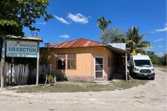
If your vehicle is 3m or taller, you’ll likely hit quite a few very low hanging branches. We have a Ford Transit high top and I wouldn’t drive the last bit to park there. Dirt path is steep but doable and not 4x4 required. It’s tranquil at this parking lot but also not the most level. We ended up parking next to Uaxactun Restaurant after eating lunch there. More central and we feel safer overnighting there than in this parking lot. |
Parking spot in AB group of Uaxactun | 17.39716, -89.63867 | |
|
asobolife.com
|
We ate lunch at this restaurant, which is located right on the corner. Food and drinks was 60Q each. Food is great! After we asked if we could park overnight next to her restaurant. She said it was ok and even let us use her bathroom throughout the day. We recommend this restaurant as the best place to boondock overnight. |
restaurant Uaxactun | 17.39485, -89.63352 | |
|
||||
|
ccummings208
|
Pull off for the Alum Trailhead. Room for a few big rigs right along the road. There’s a dirt road you can drive on in addition to the pull off, not sure how far it goes or where it leads. Would not recommend driving on that road unless you have a 4WD, high clearance vehicle. Gorgeous views. The trail goes about 1.25 miles downhill to Gila River, where there are tent camping sites: one right next to the river and a few more along the path to the bridge. |
Alum Trailhead | 33.15823, -108.19805 | |
|
via360graus
|
Muitos atenciosos, segurança 24h, banheiro, chuveiro, conveniência, Lugar tranquilo. Gratuito. |
Posto BR Baldessar | -27.99345, -49.57076 | |
|
||||
|
onlyME
|
2 relaxing days in the middle of nowhere, very nice place. We saw some zebras around and find the DAM too. But signs on the road would be helpful |
Omukutu (Black Rock Campsite) | -21.62456, 15.59371 | |
|
living.it.right
|
Somewhat noisy, but otherwise no issue. Bummer they don't allow dogs. We stayed for one night in our van and had no problems. OK Verizon reception (with booster). Garbages nearby and bathrooms but they weren't open when we were there maybe because of Hurricane Laura. |
Veterans Memorial Park, Lake Charles | 30.23127, -93.22122 | |

|
||||
|
El Carrito Azul
|
There is a ferry (not shown on maps me)17k per vehicle. |
Road from Puerto Lopez to Barranca de Upia. | 4.31803, -72.87110 | |
|
El Carrito Azul
|
The caretaker was a very friendly woman.Big clean pool, everything clean.This road is not very noisy.No trucks at night.The best camping spot is at the very far lower end at the viewpoint.A small island on a cliff overlooking the canyon (1vehicle). 30k pp. |
Hotel Campestre Luna Roja | 4.10286, -72.90810 | |
|
franklinkb
|
looks pretty much like the rest of the park, beautiful |
Big Bend - Croton Spring | 29.35321, -103.27828 | |
|
the.vandersons
|
They moved the office, updating location, it's by a burger king. Process same with some exceptions:
Very quick office, we didn't have to wait at all. He said when we can do it in a few days, he will process same day. |
Visa Extension - Direccion General de Migracion y Extrangeria | 13.70282, -89.24919 | |
|
akombicicleta
|
Gaz station at the entrance of the city of Barra do Corda.
|
Posto Carreteiro Alvorada | -5.46455, -45.28622 | |
|
EJ
|
Lots of litter and noisey locals drinking in the evening, but sunrise totally made up for it! We camped, the ground is very hard, bring spare pegs... |
Public lake access road | 20.28861, -103.23088 | |
|
||||
|
transhumances.eu
|
The last place where you gonna be able to buy some stuff! Nice lady, very little shop with basic food (cans, cookies, ham, cheese, beer...), but no bread when we were there. If it's close, you have her number on the door. Possible to pay by card! |
XIMENA | -53.63992, -69.64508 | |
|
tony-ontheroad
|
Big area with lots of wildcamping options. Acces road in bad condition but drivable with any vehicle. With 4x4 you can drive right up to the cliff edge for amazing views, but 2x4 have many options between the trees. Acces to the beach and a beach bar via some steep pathways. No trash bins so lots of trash laying around. Please take some with you when you drive out and let's leave this place better than we found it, otherwise we are going to loose acces to these kind of places in the future. Can get busy in the weekends. |
Fontanilla | 37.11946, -6.78727 | |
|
||||
|
Schiebockner
|
We drove up to the mirador (needed 4WD and high clearance) and spend the night there (needed a bit of patience to level out the car).
|
Lake Chicabal - NO SWIMMING | 14.79575, -91.64634 | |
|
atsukoohtake
|
Made a reservation but found the campground sparsely occupied due to early season cold temperatures. The sites were level. I had booked site 34 in the Aspen loop, which was literally right in front of the bathroom, 10 feet away. Reserve. gov doesn’t give good reference to the campground map, which makes it difficult to scope put where you will end up. Cost was only $9 with Parks pass 50% discount. |
Grand Canyon Mather Campground | 36.05046, -112.11679 | |
|
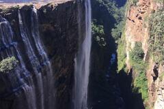
Landy-Peter
|
Beautiful waterfalls and very easy to reach. Just park at this location at the picnic spot, cross the river and walk to the viewpoint |
Magwa Walls | -31.44721, 29.63918 | |
|
||||